Stop #34: Pond Ridge Moraine
Location:
Location:
Route 191 north of Cutler. Turn off of Route 191 toward the antenna field of Cutler Naval Station, and you will be traveling along the crest of the moraine.
N 44°40’08” W 67°15’48”
Geology:
Pond Ridge Moraine: This is one of the largest, most prominent moraines in the area. It was the first such feature reported in the region in a 1935 geological survey. The moraine is about 90 feet high and 1,000 feet wide. It was formed in about 250 feet of water about 15,600 years ago. As relative sea level lowered, waves washing across the moraine gave it the smooth asymmetrical profile visible today. The age of Pond Ridge is based on the carbon14 ages of fossil remains of marine shells and seaweed found within the moraine.
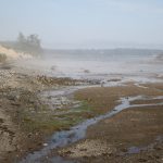
The interior of the moraine, exposed by wave action, can often be seen along the beach, where significant erosion occurs.