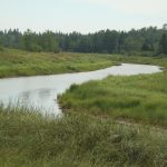
Stop #23: Salt Marsh

Location:
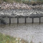
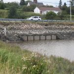
Flapper valves visible under road; remnant dykes visible in marsh.
N 44°37’05” W 67°44’55”
Geology:
Salt Marsh: Dykes north of the road were constructed in the 19th century. The dykeing technique technique came from the lowlands of northwestern Europe.
This method was used to desalt the marsh grass (hay) so it could be used for animal food. This source of hay was preferable to the enormous effort necessary to cut trees of the land, pull the stumps, plow the field and plant hay.
Flapper valves called “aboiteaux,” a term used throughout Acadia were installed in the dykes to allow fresh water to flow across and through the marsh into the sea at low tide and prevented the incoming tide from entering the marsh. The wooden remains of a flapper valve can be seen on the marsh just below the road level where the dike has been breached. Most of the old dikes and valves are in disrepair. The present road serves as a modern dike for the entire marsh, and at low tide, the functioning flapper valves can be seen. Where: Addison public boat launch.